
Walk a Kalamazoo Street Directory
The county Parcel Search is the practical first stop for a Kalamazoo street directory search. Its Street tab accepts any portion of a street number and name. A street name by itself can return a whole-street property set, while a number alone can help when the spelling is uncertain. Preserve the displayed owner name, parcel ID, situs address, mailing address, and legal description. The county record is an address-to-owner route, not a list of every person connected with the address.
- Enter the street name or number in Parcel Search and record the parcel ID, situs address, owner name, and municipality for each target parcel.
- Open the same segment in the Kalamazoo County Parcel Viewer to check parcel shape, corner lots, alleys, and adjacent street segments.
- Use the owner name, legal description, and a recent date range in the Deeds Search to identify the purchase instrument and recorded parties.
- For a known voter, use the Michigan voter address or name panels to verify only the public registration result that applies to that person and address.
- When the question is historical, compare the address with KPL criss-cross directories and old street numbering before treating a non-match as an end point.
Keep the result order from the Street tab rather than relying on a name alone. A street can cross the City of Kalamazoo, Portage, a village, or a township. The county viewer gives the shared geographic frame, but the city or township assessor is the right office for its own current detail card.
Kalamazoo Street Directory Fields
Parcel Search has three text-based modes, each useful at a different point in a Kalamazoo address inquiry. Start with Street when the address is known. Switch to Owner after a parcel result identifies an assessed owner, and use Parcel ID when the same street number could refer to different lots or a parcel has an unusual address. The county notes that linked municipal views can vary, so save the source date and the jurisdiction shown with the result.
| Parcel Search field | Entry type | Required | Kalamazoo use |
|---|---|---|---|
| Owner | Text | Optional mode | Any text is accepted. The county gives LastName FirstName MiddleInitial as a useful pattern. |
| Parcel ID | Text | Optional mode | Use a full or leading ID. Hyphenated, spaced, and unpunctuated examples are accepted. |
| Street | Text | Optional mode | Enter any part of street number and name. A street name alone can return all listed properties. |
| Mode tabs | Tabs | One selected | Choose Owner, Parcel ID, or Street rather than combining fields on one query. |
Try street, avenue, and road variants before deciding the record is absent. Historic names and a number-only search can also matter. The visible result fields differ by municipality, which is why the returned parcel ID and legal description are stronger pivots than a broad street-name match.
Kalamazoo Address Records
A street-level search relies on several records with different limits. The parcel card ties an address to an assessed owner and current tax context. GIS supplies geometry and layers. Recorded documents establish a dated land transaction. City permit material can show work activity at a city parcel. The voter tool is a confirmation screen for a known person, while a broader public voter-file request follows a separate written process. KPL directories provide historical address-to-name evidence rather than current status.
| Address record | Local keeper | Street evidence | Access route |
|---|---|---|---|
| County Parcel Search | Equalization and municipal assessor links | Owner, parcel ID, street result, situs and mailing context | Free owner, parcel, and street modes; Room 404 counter |
| GIS parcels | County Planning and GIS | Parcel polygon, aerial, tax-map, soil, and wetland context | Public viewer with click, pan, zoom, and select tools |
| Recorded land documents | Register of Deeds | Parties, dates, legal descriptions, book/page or document number | Free index; image and copy charges apply |
| City BS&A and permits | City assessor and Building Department | City-only tax, sale, building, and inspection details | Address-first portal and office or records-request route |
| Directories and criss-cross books | Kalamazoo Public Library | Earlier occupants, street order, and address sequence | Local History Room, microfilm, catalog, and digitized links |
The chain becomes more reliable when the parcel ID and legal description stay attached to the address. Street numbers can change, parcels can split or combine, and a similar number on a different segment may be a different lot. A permit, deed, or tax tab should be read as evidence for its own date and purpose.
Map a Kalamazoo Street Search
The county GIS viewer is the visual companion to text searches. Select a parcel polygon, then pan and zoom along the street to compare gaps, frontage, corner lots, and nearby parcels. The county lists parcel geometry, tax maps, aerial imagery from 2018 through 2023, soils, and National Wetland Inventory layers. Its parcel layer is updated annually to align with the tax roll. Aerials and map layers provide context, not a live account of a parcel.
| Parcel layer | Select a polygon and follow its available attribute link or identifier. |
|---|---|
| Tax maps and aerials | Compare the parcel setting and historical visual context, not ownership by themselves. |
| Identify, pan, and zoom | Browse a street segment and check adjoining parcel geometry. |
| Measure | Use only as approximate map context. County measurements are not legal survey dimensions. |
The county expressly treats the viewer as informational, not a recorded survey or a tool for precise measurement. Confirm current ownership with the municipality. For properties inside the city, the City property-tax information route adds address-first tabs for tax, sale, building, and permit details.
Note: A map click shows geographic context, while the recorded legal description and current municipal record remain the sources for confirmation.
Kalamazoo Recorded Deed Trail
A deed trail begins with the current parcel result, not an address-only document search. Use the current owner and a recent date range in Deeds Search, then identify the purchase instrument from the party pair, date, document type, parcel number, and legal description. Search the seller as an earlier grantee to move backward. If a parcel was split or combined, follow the parent parcel or recorded plat rather than forcing the present parcel number into an older record.
The Kalamazoo County Deeds Search is the source shown below. Its free basic search offers name, date range, liber/page, document number, and parcel-number routes. The Register of Deeds advises using a party name because an address is not required on every recorded document.
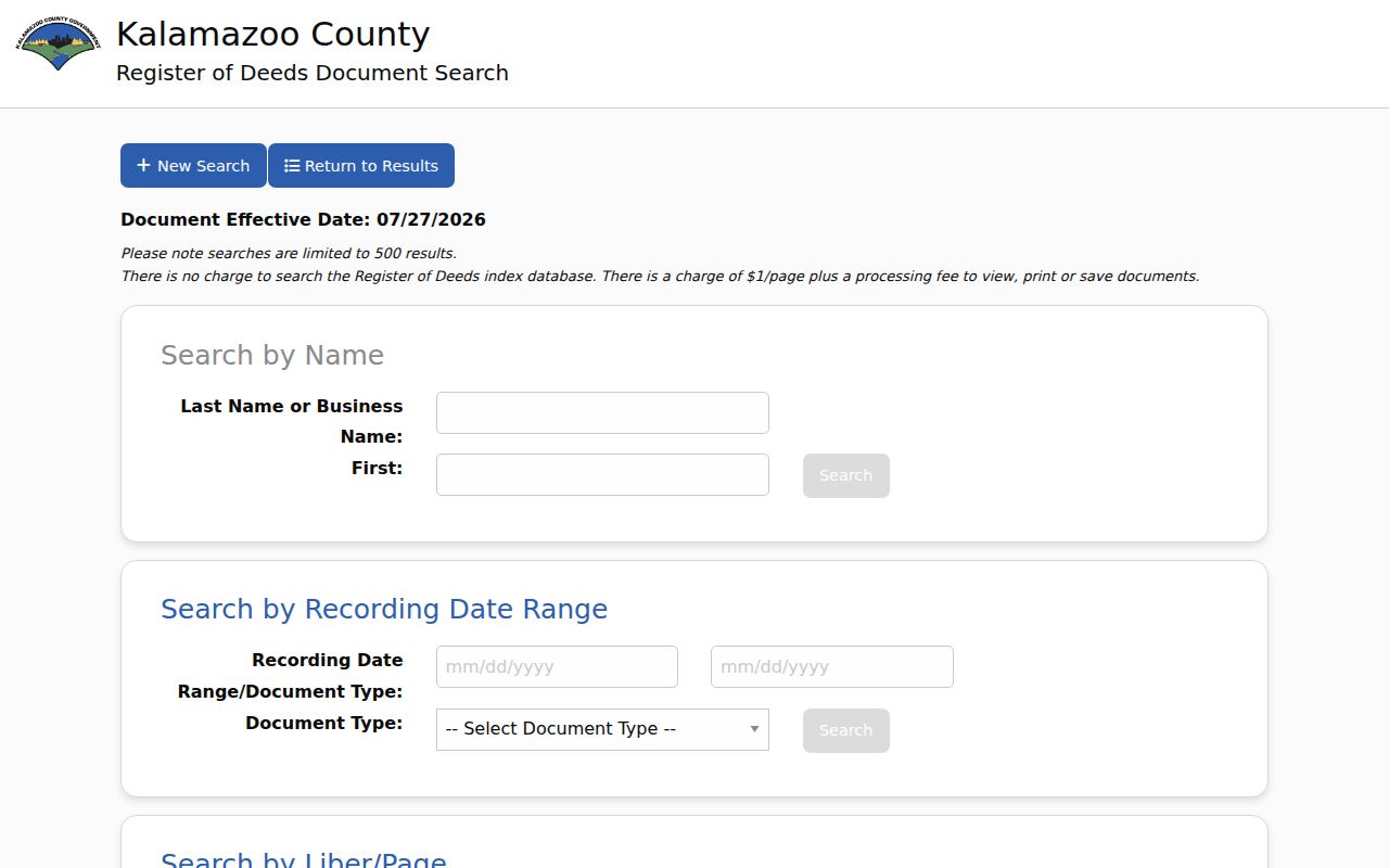
The interface supports a documented street-by-street trail when each search is narrowed by name and date. Results can reach 500, and image viewing, printing, or saving is charged at $1 per page plus a $2.50 technology fee. The county reports searchable land-record images from 1831 and a complete index from 1984, so those coverage statements should not be treated as the same thing.
Free public workstations, a phone call to the deeds desk, copy requests, and the counter are additional routes when the portal does not resolve an older book, a spelling variant, or a prior parcel. The office does not conduct title searches or provide legal advice, so a chain should be preserved as records research rather than a legal conclusion.
Kalamazoo Address Record Keys
Three address terms prevent many errors in Kalamazoo street work. The situs is the physical location used by street search, maps, permits, and city tax pages. A mailing address is where tax notices go and can lead to an owner elsewhere, a trust, or an estate. The legal description and parcel ID connect present assessment data to a plat, lot and block, or metes-and-bounds language in the recorded land file. None of these labels can by itself establish every person at a location.
- Parcel
- A county property identifier used to connect assessment records and map views. It can change after a split, combination, or municipal transfer.
- Situs address
- The physical parcel location. It is the address most directly used for street search and GIS work.
- Plat
- A recorded map or subdivision record that can preserve lot and block links when an address has changed.
- Criss-cross directory
- A reverse directory arranged from address to listed name. KPL’s oldest local coverage begins in 1954.
This distinction is especially important where the same street crosses municipal lines. The county page links municipal assessors because a detailed card may live with the city or township. A homestead indicator, tax value, sale history, or building description is property evidence, not a complete household roster.
Kalamazoo Voter Address Limits
Michigan’s Voter Information Center is designed to confirm a known registration, polling information, and related election details. Its name panel requires first name, last name, birth month, birth year, and a five-digit ZIP code. Its address panel requires street address, city, state, and ZIP, with apartment or lot as an optional field. That makes it useful for checking a specific match, not for producing a bulk street roll.
A public QVF extract is a separate records process. The state says a request can include name, residential and mailing address, year of birth, registration date, status, voter ID, and requested history, but excludes full birth date, phone, email, license or ID number, signature, and protected data. The written request form offers scopes such as county, jurisdiction, district, and precinct, with delivery by pickup, FTP, or mail.
A non-match does not settle a street question. It can reflect a spelling difference, address change, inactive or cancelled status, protected record, or no registration. The County Clerk is the local election office, and historical poll books were not located as an online county database; the clerk, KPL, WMU, and the Library of Michigan are the documented fallback contacts for older material.
Kalamazoo Street Numbering Bridges
Modern street numbers do not always lead cleanly into a historic Kalamazoo address search. The city adopted the Philadelphia numbering system in 1883, using Michigan Avenue, then Main, and Burdick as axes. Earlier numbering could begin from the river and Main Street. Another citywide change occurred in 1925, and no 1925 directory is available to explain the transition.
Kalamazoo Public Library advises comparing 1924 and 1926, checking the same name and the immediately lower and higher addresses. The 1932 Sanborn map can help bridge old and new numbering. Historic name changes also matter: Michigan Avenue was Main, and research records examples such as Cork and St James, Oakland Drive and Asylum, Riverview and Seminary, and Vine and Rice.
For earlier address evidence, use KPL’s city directory collection and compare the entry date with the deed or parcel date. The historical shelf is treated in detail on the Kalamazoo city directories page; here, the crucial point is to retain both old and current address forms in the street research notes.
Kalamazoo Street History Clues
When an address leads to a prior household or a block history, use dated sources in sequence. Recorded land images reach back to 1831, but the county describes the complete deed index as beginning in 1984. KPL’s criss-cross run begins in 1954. The library also holds bound Sanborn volumes for 1908, 1932, and 1957, with microfilm extending to the early 1880s. Each source has a different clock and purpose.
Sanborn maps are useful for building footprint, materials, stories, porches, outbuildings, and street geometry. They are not occupant rolls. A KPL directory entry can locate a person at an address, while a deed can document a recorded transaction and a Gazette citation can point to a dated newspaper item. Comparing them can support a historical interpretation, but a conflict should remain visible rather than being forced into one answer.
Note: A current parcel search, a historic directory, and a deed may all describe the same location at different dates and for different purposes.
What Kalamazoo Street Searches Omit
Public address records have real boundaries. Parcel and deed data can identify assessed owners and recorded parties, but do not enumerate all occupants. Mailing addresses are not proof of residence. The map does not reveal utility customers, delivery information, or a private association roster. The voter lookup is not a street-wide result tool, and sensitive voter fields remain withheld. Motor-vehicle address information is closed to routine public use under driver-data privacy rules.
The Michigan Address Confidentiality Program can provide a designated address and mail-forwarding channel for eligible participants. Its safeguards, and the voter system’s protected data rules, matter whenever a street record is being compared with another public source. Use the narrowest record needed for a personal, lawful question, preserve record dates, and ask the relevant custodian to correct a mistaken official record.
Lawful use. Kalamazoo street and address records are for legitimate personal research. Do not use record details to stalk, harass, intimidate, or harm anyone, and do not attempt to expose protected addresses.